
Erection of Dwelling, Chorley
Case Study Reference: 14-02-11
Planning Authority: Chorley Council
Planning Reference: 11/00460/FUL and 14/00255/DIS
Synopsis:
Given the sensitive nature of the development (residential) and the history of the site, a contaminated land planning condition was attached to the decision notice for the proposed development.

The first stage of discharging the condition was to prepare a Phase I desk study report in order to determine if the site has the potential to be impacted by elevated levels of contamination, and to determine the source as well as the likelihood of the risk occurring.
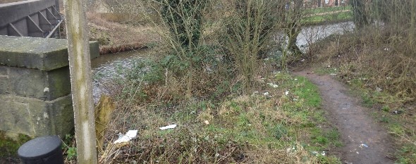
A desk study determines what issues relating to historical contamination may affect the site, this is undertaken by reviewing the site history using a combination of O.S. maps, aerial, plates and street level imagery, a review of data held by regulatory bodies (Environment Agency, local authority, BGS etc.) as well as a site walkover survey.
 The history of the site and surrounds were researched using a
  combination of Ordnance Survey (O.S.) maps, street level imagery and aerial plates, this revealed the site had not been developed, street level imagery confirmed the site comprised of an open parcel of land adjacent to the Leeds-Liverpool canal. The maps identified a sewage works and a old reservoirs in close proximity to the site.

The planning history of the site was reviewed, whilst a number of previous applications were noted, no salient information was obtained from the review of the associated documents.
 The published geological maps identified the drift soils as Till which was underlain by the Millstone Grit formation. Deposits of alluvium were npted on the eastern boundary of the site, which is a naturally occurring source of ground gases.
Data provided by regulatory bodies confirmed the presence the sewage works and old reservoir as well an electricity substation on the western boundary fo the site.
 On completion of the desk based research a site reconnaissance visit was undertaken, this confirmed the site was an open parcel of land with a track leading to the adjoining canal. The substation adjoining on the site was an open air substation.
Once the walkover survey was completed a qualitative risk assessment was undertaken on  the potential sources of contamination identified in the desk study report in order to determine if any warranted further investigation, this concluded that the made ground on the site as well as the alluvium warranted further works.
In lieu of site investigation remediation in lieu of investigation was proposed.

The Phase I report was submitted to discharge the condition (14/00255/DIS)
