Residential Development, Station Close, Radcliffe, Manchester, M26 4GW
Case Study Reference: CS19-01-16
Planning Authority: Bury Metropolitan Borough Council
Planning Reference: Bury Metropolitan Borough Council and 63002
Synopsis:
As the site was within a ‘Development High Risk Area’ as defined by the Coal Authority a Coal Mining Risk Assessment was required to support the planning application in order to demonstrate that the site can be safely developed.
The assessment comprised of the review of the published geology provided by the British Geological Survey (BGS) as well as borehole records in the public domain as well as information held by the Coal Authority.
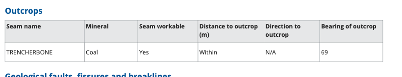
The published geology revealed the site was underlain by Devensian Till (clay) and Lower Pennine Coal Measures. No borehole records were available in the vicinity of the site.
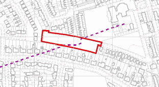
Information provided by the Coal Authority revealed they believed a coal seam (Trencherbone) outcropped on the site and there was thew possibility of shallow unrecorded worked coal seams.

Given the potential risk to surface stability further works including the sinking of three rotary boreholes to 30mbgl as trial trenches if required were proposed.
The report is available as part of the documentation supporting the application (page 2 identified as ‘Coal Mining Risk Assessment and plan 19-1-16 Rev 0’ dated 1st February 2019) as well as the formal acceptance of the report and removal of the objection by the Coal Authority (‘Coal Authority – withdraw objection – recommend co’ dated 12th February 2019).