
Erection of one three-bedroom dwelling, Heywood
Case Study Reference: 15-07-08
Planning Authority: Rochdale Borough Council
Planning Reference: 14/00533/FUL and 15/01471/DOC
Synopsis:
Given the sensitive nature of the development (residential) and the history of the site a contaminated land planning condition was attached to the decision notice for the proposed development.

The first stage of discharging the condition was to prepare a Phase I desk study report in order to determine if the site has the potential to be impacted by elevated levels of contamination, and to determine the source as well as the likelihood of the risk occurring.
 A desk study determines what issues relating to historical contamination may affect the site, this is undertaken by reviewing the site history using a combination of O.S. maps, aerial, plates and street level imagery, a review of data held by regulatory bodies (Environment Agency, local authority, BGS etc.) as well as a site walkover survey.
The history of the site and surrounds were researched using a combination of Ordnance Survey (O.S.) maps, street level imagery and aerial plates, this revealed the site was initially undeveloped (1851) and by the 1891 map the site had been developed and was likely occupied by dwellings. The 1968 and 1975 mpas indicate the site had been cleared.
A number of reservoirs were identified in close proximity to the site as well as a sand pit and a mill.
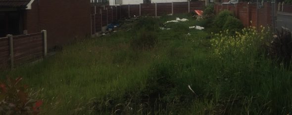
Street level imagery confirmed the site formed part fo the garden of the adjoining property.

The planning history of the site was reviewed as part of the desk based research and the reports associated with any previous application were located and studied, no salient information was obtained
The published geological maps identified the site as being underlain by Devensian TIll which in turn were underlain by the Pennine Lower Coal Measures.
Data provided by regulatory bodies identified a number of reservoirs and sand pits, confirming the details obtained formt he review of the O.S. maps.
 On completion of the desk based research a site reconnaissance
 visit was undertaken, this confirmed the site formed part of the garden of the adjoining property, building material and fly tuping was noted on the surface of the site.
As part of the walkover survey two hand held trial pits were excavated on the site, there was no evidence of made ground below the surface at either location.
Once the walkover survey was completed a qualitative risk assessment was undertaken on the potential sources of contamination identified in the desk study report in order to determine if any warranted further investigation, this concluded that the made ground identified on the site as well as the in-filled land within 250m of the site were potential sources of contamination.
It was concluded that remediation in lieu of further works was the preferred option with the removal of made ground from the site and the incorporation as gas protection measures was the preferred option.

The desk study rpeort was submitted to partly discharge the contaminated land planning condition (15/01471/DOC)

