

Change of Use of Existing Buildings, Owler Lane, Birstall, WF17 9BW
Case Study Reference: 15-01-05
Planning Authority: Kirklees Council
Planning Reference: 2014/62/94020/E0
Synopsis:
Given that the subject site was within a ‘Development High Risk’ Area’ the Coal Authority objected to the application until a Coal Mining Risk Assessment was prepared for the site to assess the risks posed by the legacy of coal mining in the area.
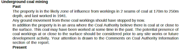
Large and small scale geological maps confirmed the bedrock comprised of Lower Pennine Coal Measures and that the Flockton Thin Coal (FN) seam appears to outcrop on the southern boundary of the site. The seam thickness was recorded to be between 0.3 to 1.4m thick.
BGS boreholes indicated that weathered coal was present in close proximity to he surface in the area of the site.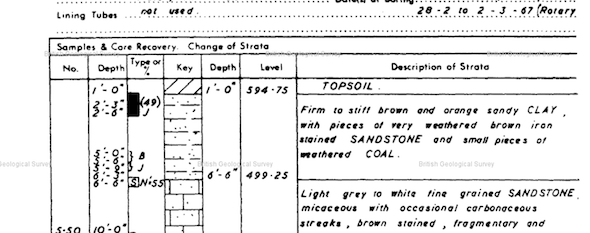
As the proposed development was change of use with limited building works, it was concluded that remedial measures (foundations to withstand a collapse etc.) were an appropriate alternative to intrusive works,
The recommendations of the report were accepted (the memo can be accessed here) and the objection to the application lifted.